POTENTIAL FLOODPLAIN DISCREPANCY
✅ Key Factual Points: Eagle Lake OHWM & Water Level History
Historical Fluctuations:
Eagle Lake has varied by up to 7 feet below current levels, reflecting a dynamic hydrological cycle.OHWM Determinations:
1968: Vince McCann established the Ordinary High Water Mark (OHWM) at 898.4 ft NGVD29 (≈897.96 ft NAVD88).
1976: Don Bissell reaffirmed this elevation—no change warranted.
1982: Inspection showed button bush growing 1.3–2 ft below water level of 899.06 ft NGVD29 (≈898.62 ft NAVD88), but no evidence to revise OHWM.
Bilow’s Position (Dec 16, 1982):
High water levels are natural, not justification for OHWM revision.
Warned against adjusting OHWM based on temporary extremes.
Reaffirmed 898.4 ft NGVD29 / 897.96 ft NAVD88 as valid OHWM.
Regulatory Guidance:
Recommended enforcement via Section 3(d) or 3(e) of the Inland Lakes and Streams Act.
Supported use of the Wetlands Protection Act for adjacent wetlands.
Urged protection during high water without altering OHWM.
Documentation Notes:
Bilow committed to providing a map of the Public Access Site (NW shore, per Mr. Milbeck).
Included a list of OHWMs established by the Engineering Division for staff reference.
📜 Key Factual Points: August 17, 1988 – Eagle Lake OHWM Memo
Concern Raised:
On July 27, 1988, Glen Haney (Kalamazoo County Drain Commissioner) reported Eagle Lake’s water level was exceeding the OHWM set in 1982.
Haney had been present during the original OHWM determination.
Legal Status:
Eagle Lake does not have a court-established lake level via Circuit Court.
High water was causing property damage, prompting resident action.
Resident Response:
No permit required for pumping, per guidance from Jeff King.
Technical Validation:
Lake level was ½ inch above OHWM at time of memo.
The 1982 OHWM was set when lake was already 1.6 ft above benchmark, reinforcing its validity.
Benchmark and OHWM documentation were shared internally for review.
Regulatory Position:
Memo reaffirms that fluctuations are natural and do not justify OHWM revision.
Emphasizes regulatory management tools over reactive elevation changes.
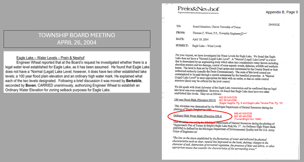
📅 Key Factual Points: April 2004 – Eagle Lake Floodplain & Water Level Summary
No Legal Lake Level:
On April 19, 2004, Engineer Thomas C. Wheat confirmed Eagle Lake does not have a court-established “Normal Lake Level.”
Established Elevations:
100-Year Floodplain:
902.00 ft NGVD29 (≈901.56 ft NAVD88)
Ordinary High Water Mark (OHWM):
Reaffirmed at 898.40 ft NGVD29 (≈897.96 ft NAVD88)
Determinations supported by MDNR, MDEQ, and U.S. Army Corps of Engineers.
Planning Integration:
At the April 26, 2004 Township Board meeting, Wheat presented these findings.
Board authorized him to establish an Ordinary Water Elevation for zoning setback purposes.
This marked a formal move to assign benchmarks for Eagle Lake, which differed from the state
📍 Key Factual Points: April 3, 2007 – ZBA Elevation & Variance Deliberations
Variance Request:
Concerned lot coverage and setbacks for a lakefront parcel on Eagle Lake.
Debate centered on which elevation should define the buildable area.
Elevation References:
Historical reference: 898.4 ft NGVD29 (OHWM).
Applicant’s survey cited 899.84 ft as high water elevation, used in board’s decision.
Board Deliberation Highlights:
Mr. Sprau recommended using 899.84 ft as boundary for lot coverage.
Attorney Thomsen noted township engineer and surveyor supported using high water elevation, not the meander line.
Ordinance did not define lakefront platted lot area.
Variance Outcome:
Approved 20% lot coverage, measured from 899.84 ft elevation to street and side lot lines.
Setback requirement: No structure within 46 ft of 899.84 ft elevation, based on neighboring averages.
Motion passed 4–1.
Dissenting Vote:
Mr. Weurding opposed, citing:
Prior neighbor complaints about denied use beyond meander line.
Cited the need for consistent treatment.
🗓️ Key Factual Points: June 2007 Newsletter – ZBA Elevation & Zoning Impacts
ZBA Meeting Reference:
The newsletter highlights the April 3, 2007 Zoning Board of Appeals (ZBA) meeting as pivotal for zoning changes affecting lakefront parcels.
This meeting directly addressed lot coverage and setbacks in relation to water elevation.
Elevation Used:
The “high water line” was defined by survey at 899.84 ft elevation.
This elevation was used to calculate the buildable footprint of lakefront lots.
Represents a shift from earlier references like the Ordinary High Water Mark (OHWM) of 898.4 ft NGVD29, used historically.
Zoning Impact:
Residents were encouraged to review the April 3 ZBA minutes and consult township officials for clarification.
Contextual Notes:
The newsletter also discusses the special assessment district approved on April 23, 2007, and ongoing efforts to manage water levels and invasive species.
📍 Key Factual Points: Eagle Lake Water Level Policy – May 29, 2008 Survey & ZBA Context
Background:
Eagle Lake has no surface inlet or outlet, leading to low water levels during dry periods.
Since December 1965, water has been pumped from a well at the east end to stabilize levels.
Pump rate: 1,000–1,200 gallons per minute.
May 29, 2008 Survey – Prein&Newhof:
Commissioned by the Eagle Lake Texas Association (ELTA) to establish an Ordinary High Water Mark (OHWM).
Survey determined the OHWM to be 899.84 ft elevation.
This elevation became the target level for pump operation and lake management.
ZBA Connection – April 3, 2007:
Just 14 months earlier, the Zoning Board of Appeals used the same 899.84 ft elevation to define the buildable footprint for lakefront parcels.
This alignment between zoning decisions and hydrological management reinforces the elevation’s regulatory significance.
Unresolved Survey Methodology:
It remains unclear how Prein&Newhof’s 2008 survey arrived at the exact same elevation (899.84 ft) used in the 2007 ZBA meeting, especially given that it was presented as a new survey.
No documentation has been provided explaining whether the 2008 OHWM was independently verified or simply adopted from prior zoning deliberations.
Pump Operation Policy:
Pump runs only as needed to maintain lake level near the 899.84 ft OHWM.
Oversight by 2–3 designated ELTA personnel.
In 2014, ELTA anticipated upgrading to a “hardened site” OHWM marker for improved monitoring.
📈 Key Factual Points: May 2009 Newsletter – Rapid Water Rise After Pump Policy Adoption #1
Pump Policy Adoption:
On June 2, 2008, the Eagle Lake Texas Association Board approved a formal lake water level and pump operation policy.
Policy was based on a Prein&Newhof survey that established the Ordinary High Water Mark (OHWM) at 899.84 ft elevation.
Pump Operation Rules:
April 15–Sept 15: Pump runs if lake is ≥3 inches below OHWM; shuts off when lake reaches that threshold.
Sept 16–April 14: Pump remains off unless lake drops ≥7 inches below OHWM.
Pump also remains off when lake is frozen.
Rapid Water Rise:
As of May 15, 2009, lake level was 7.5 inches above the OHWM (899.84 ft).
Pump had been turned off since Sept 9, 2008, per policy.
Rise attributed to higher-than-normal snow and rainfall, but the timing—less than a year after policy adoption—raises questions about policy responsiveness to hydrological extremes.
Zoning Context Reminder:
The 899.84 ft elevation was also used in the April 3, 2007 Zoning Board of Appeals meeting to define buildable area—further reinforcing its regulatory significance.
📈 Key Factual Points: 2018–2022 Elevation Escalation – Eagle Lake Rapid Water Rise #2
Historical Benchmark:
The 100-year floodplain for Eagle Lake has long been documented at 901.6 ft NAVD88.
2018 Update – Prein&Newhof Letter:
Reaffirmed the 901.6 ft NAVD88 floodplain.
Recommended a design elevation of 903.0 ft NAVD88 for new development.
Justification: Elevated groundwater and updated elevation data warranted a precautionary approach.
2022 Update – EGLE Letter to Molnar Construction:
Again cited 901.6 ft NAVD88 as the historical floodplain.
Recommended an even more conservative 904.0 ft NAVD88 elevation for future development.
Rationale: Persistent high groundwater levels and increased flood risk.
Planning Implications:
The rising recommended elevations reflect a trend toward more resilient infrastructure standards.
Emphasizes the need to adapt zoning and site design to evolving hydrological realities.
1982 & 1983

1988

2004
APRIL 3, 2007

JUNE 2007

MAY 2008

JUNE 2009

NOVEMBER 2018

JULY 2022

WHICH FLOODPLAIN IS CORRECT 901.6 ft | 903 ft | 904 ft
FOR NEW CONSTRUCTION?
